The counties of Allegheny and Washington maintain a trail called the Mountour Trail. It starts at the Ohio river in a town called Coraopolis, runs down through Robinson Township, home to the local IKEA, then runs runs for 45-miles and spans several towns and cities in South-West Pennsylvania before ending in Clairton on the Monongahela River. Along it you will find camp sites, trail heads for hikes and, as I learned on my ride, lots of scenic bridges and tunnels.
Whenver I do a longer bike ride, I prefer to begin and end the journey from my apartment and ideally be on my bike the entire time. That is, I prefer not to drive with my bike to some place. Sometimes (like on this ride), doing that would make the route longer than I can handle or would require riding with fast moving traffic for longer than I’d like. Since I don’t own a car, I try to use public transport to make these rides accesible. This post is about one such ride. If you live in Downtown Pittbsurgh or futher East, the Montour Trail is a perfect way to spend some quality time on not only your bike, but also on the bus and light rail systems.
Getting To The Trail
From various points in the city you can board catch the 28X bus toward the airport. This route runs busses with racks that can carry up to two bikes on the front. Take it to the Robinson Town Centre stop. From there it’s less than a mile to the trail head. The road leading there is only marked with sharrows so you will be riding with potentially angry motorists here! Fortuanately it’s all downhill at a farily steep grade. So, it shouldn’t be too hard to move fast enough to avoid drawing their ire. For this reason, I do not recommend ending the route here. Climbing up an insanely steep hill for a mile with cars breathing down your neck is an awful way to end an otherwise amazing ride.
The Ride
The Montour Trail is great! There are only a handfull of at-grade crossings with car traffic, nearly all of which are across low throughput back roads. Much of the trail is covered by trees, so you have plenty of shade during Spring and Summer. There are portajohns every few miles, ditto for water fountains, benches, and picnic areas. It’s also pretty easy to deviate from the trail into the various towns it passes through for food. I didn’t do that on this ride, though. I packed snacks and stopped at a bench every 10 miles to eat and rehydrate.
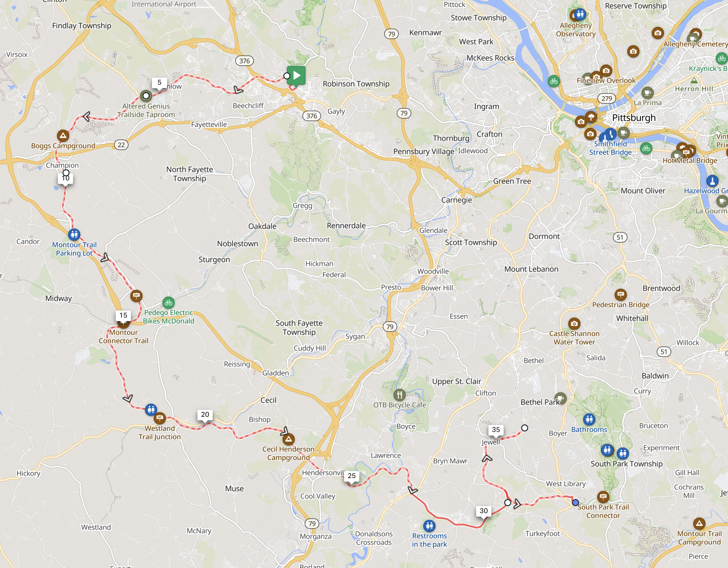
I posted the route on Ride with GPS. From there you can download it as a GPX file to put on a watch or bike computer. You won’t need the guidance, though. The trail is very clearly marked. At the time of writing this is the longest bike ride I’ve ever done, at 40 miles and 1,255 feet of elevation gain. I took my Montagna Mountain Sport for this ride.
There’s a bike shop called The Tandem Connection in Hendersonville, close to the mid-point of the route. I broke a spoke on my rear wheel at the 15 mile mark, which caused the wheel to come out of true and rub on my chain stays. It wasn’t a fatal failure, but I forgot my wrench at home and I couldn’t adjust the wheel to avoid rubbing. I was worried I would be dealing with the awful sound caused by this for the rest of the ride (or worse, I’d ruin my tire). The mechanic at this shop lent me a wrench and I was able to finish the ride without any severe failures. They also have Pizza! Check them out.
Getting Back To Pittsburgh
The trail eventually passes through the town of Library, which is the end of the silver line on the regional light rail system. Library station is a high-platform station, so you can board with a bike there. Take the silver line to Washington Junction (another high-platform station) and transfer to the blue line to get back Downtown. The blue line will come to the same platform as the silver line, so all you have to do is get off and wait for the next train. Every Downtown station is a high-platform station. From there you can bike back home or take a bus for the last mile. I took the P1, since I live along the East Busway.